Photogrammetry for car-accident documentation: a fast 3D scene
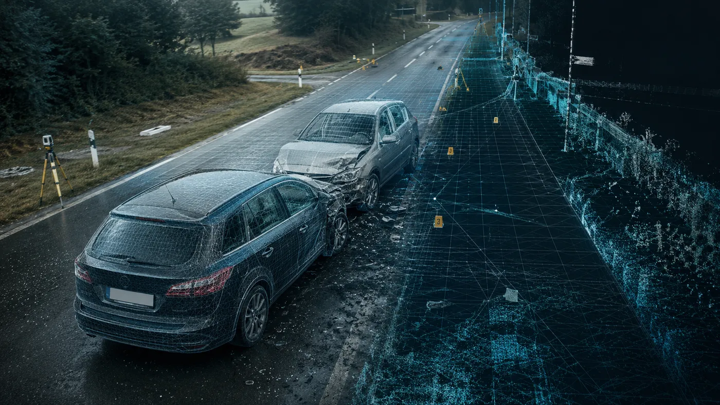
At a road accident, every minute of road closure means congestion, diversions and lost working hours — yet investigating the scene must be both fast and accurate. Photogrammetry allows complete documentation of the scene in a few minutes, using only drone and ground photographs, with all precise calculations (distances, angles, brake marks) carried out later at the desk on a 3D model. This article explains why photogrammetry is an efficient method for documenting car accidents and how the result is obtained.
The three requirements of scene documentation
- Nothing can disappear: the scene must be mapped as quickly as possible so that all details remain intact.
- As much detail as possible: the data is later used by police and insurance companies for specific calculations.
- Precise measurements at the desk: investigators need tools that allow exact determination of the distances between vehicles, the angle of impact, brake marks and final positions.
The limits of traditional methods
Traditional accident documentation came in two variants, each with drawbacks:
- The 3D laser scanner delivers very good results, but it is expensive, and the limited number of devices causes delays and complicated logistics.
- A manual sketch plus around 100 photographs documents the scene but offers a poor perception of the situation, and sketching a large scene is time-consuming and limited in precision.
Mapping the scene through photogrammetry
The process starts with importing all photographs (from the drone, from the ground, from witnesses) into the photogrammetry software. The bundle-adjustment stage recognises the common points between images and generates a point cloud. Reconstruction then produces a dense 3D point cloud and a 3D model of the scene, on which experts use the integrated CAD functions to extract angles, distances and exact relationships between objects.
Deliverables and benefits
On-site image processing takes a matter of minutes, and full desktop processing a few hours. Deliverables include:
- a 3D model in OBJ format;
- a 3D sketch with vector CAD lines (distances, angles, measurements), exportable to DXF;
- an orthophoto map in JPG format;
- a KMZ export ready for Google Earth.
The benefits are clear: immediate visualisation of the scene, material useful for presentation in court, time saved in data collection and processing, high precision in calculations, and lower acquisition costs than other modern solutions.
Conclusion
Photogrammetry offers a fast, accurate and accessible way to document a road-accident scene, freeing the road sooner while preserving all data needed for later analysis. For photogrammetric documentation of a scene or a site, contact us.